Lesson Plan: Globe, Maps, and Types of Governments
Grade Level: Grade 6 Subject: Social Science (Geography and Civics) Duration: 3 Weeks (15 class periods, 40 minutes each) Aligned with: NCERT Class 6 Geography Chapters 2 (Globe: Latitudes and Longitudes) & 4 (Maps); Civics Chapter 3 (What is Government?)
Inline Questions
Objectives
By the end of the three weeks, students will be able to:
- Explain the globe as a true model of the Earth and identify key latitudes/longitudes.
- Describe heat zones and their importance.
- Understand map components (scale, symbols, direction) and differentiate types of maps.
- Explain the need for government, its levels in India, and compare types (democracy vs. monarchy).
- Locate places on a globe/map and relate concepts to India (e.g., Tropic of Cancer, Indian democracy).
- Develop skills in observation, sketching, and critical thinking about governance.
Materials Needed
- Physical globe (at least one for demonstration; inflatable/plush for groups if possible)

Amazon.com: Pocket Earth HUGG-A-PLANET | Soft Plush Globe for ...
- Atlas, political and physical maps of India/world
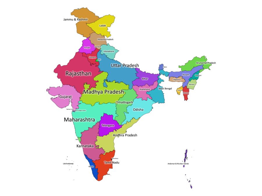
India labeled map | Labeled Maps
- Charts of latitudes/longitudes and map symbols
- Worksheets (locating places, map sketching, comparison tables)
- Projector/smartboard for diagrams (optional)
- Crayons, rulers, blank paper for drawing maps
- Flashcards with government terms (democracy, monarchy, election)
Week 1: The Globe – Latitudes and Longitudes
Focus: Understanding the globe as Earth's model and grid system.
Day 1: Introduction to the Globe Objective: Understand why we use a globe. Activities:
- Warm-Up (5 min): Ask: "How would you show the round Earth on paper?" Discuss flat maps vs. globe.
- Direct Instruction (15 min): Explain globe as a miniature Earth; show axis, hemispheres.
Circles Of Latitude And Longitude
- Activity (15 min): Pass globe; students locate India, continents, oceans.
- Wrap-Up (5 min): Discuss advantages of globe over flat maps. Homework: Draw a simple globe and label equator.
Day 2: Latitudes Objective: Identify key latitudes. Activities:
- Recap (5 min): Review globe features.
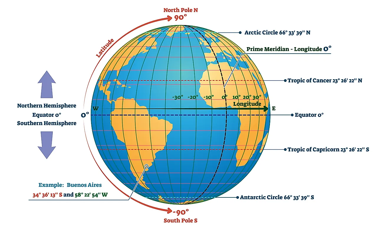
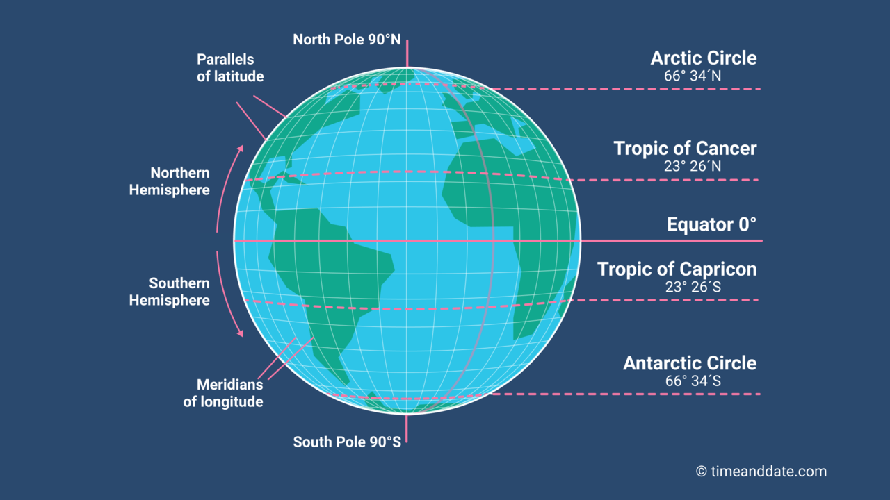
- Direct Instruction (10 min): Explain parallels; focus on Equator, Tropic of Cancer (passes through India), Tropics, Circles.
What Is Longitude and Latitude?
- Activity (15 min): Worksheet – Mark latitudes on outline globe.
- Wrap-Up (5 min): Why is India in Torrid Zone? Homework: List states Tropic of Cancer passes through.
Day 3: Longitudes and Time Objective: Understand longitudes and time calculation. Activities:
- Warm-Up (5 min): Quiz on latitudes.
- Direct Instruction (10 min): Explain meridians, Prime Meridian, IST (82.5°E).

World map with circles of latitudes and longitudes, showing ...
- Activity (15 min): Calculate time difference (e.g., India vs. Greenwich).
- Wrap-Up (5 min): Role-play Earth rotation for day/night. Homework: Find longitude of your city.
Day 4: Heat Zones Objective: Describe Earth's heat zones. Activities:
- Recap (5 min): Longitudes quiz.
- Direct Instruction (10 min): Torrid, Temperate, Frigid Zones – link to climate.
- Activity (15 min): Group coloring of zones on world outline.
- Wrap-Up (5 min): How zones affect life in India. Homework: Write 2 features of Torrid Zone.
Day 5: Review and Application Objective: Locate places using grid. Activities:
- Activity (20 min): Globe hunt – Find coordinates of cities (Delhi, Mumbai).
- Worksheet (15 min): Fill grid questions.
- Wrap-Up (5 min): Share learnings.
Week 2: Maps – Components and Types
Focus: Reading and understanding maps.
Day 6: Map Basics Objective: Understand map elements. Activities:
- Warm-Up (5 min): Globe vs. map limitations.
- Direct Instruction (10 min): Scale, direction, symbols, colors.
- Activity (15 min): Identify symbols on India map.

Types of Maps Notebook Infographic
- Wrap-Up (5 min): Importance of scale. Homework: Draw 5 conventional symbols.
Day 7: Types of Maps – Physical & Political Objective: Differentiate physical and political maps. Activities:
- Recap (5 min): Map elements.
- Direct Instruction (10 min): Show examples; physical (mountains, rivers), political (boundaries).
- Activity (15 min): Compare India physical vs. political map.
- Wrap-Up (5 min): Why political maps for governments? Homework: List 3 differences.
Day 8: Thematic Maps and Sketch Objective: Explore thematic maps and create sketches. Activities:
- Warm-Up (5 min): Review types.
- Direct Instruction (10 min): Thematic (population, rainfall).
- Activity (15 min): Draw sketch map of school to home.
- Wrap-Up (5 min): Uses of thematic maps.
Day 9-10: Map Reading Practice & Review Activities: Group work – Interpret atlas maps; quiz on components/types; project: Simple thematic map of classroom (e.g., seating by height).
Week 3: Types of Governments
Focus: Understanding government and its forms.
Day 11: What is Government? Objective: Explain need and levels of government. Activities:
- Warm-Up (5 min): "Who makes rules at home/school?" Link to government.
- Direct Instruction (10 min): Functions, levels (local, state, central in India).
- Activity (15 min): Discuss examples (panchayat, parliament).
- Wrap-Up (5 min): Why need laws? Homework: List 2 services by government.
Day 12: Democratic Government Objective: Understand democracy. Activities:
- Recap (5 min): Government functions.
- Direct Instruction (10 min): Universal adult franchise, elections, India's republic.
- Activity (15 min): Mock voting in class.
- Wrap-Up (5 min): "Rule by the people."
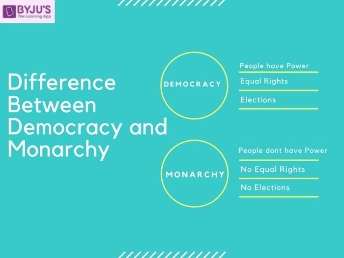
Day 13: Monarchy and Comparison Objective: Compare monarchy and democracy. Activities:
- Warm-Up (5 min): Examples of kings today.
- Direct Instruction (10 min): Absolute vs. constitutional monarchy.
specialneedsforspecialkids.org
- Activity (15 min): Debate – Advantages of democracy.
- Wrap-Up (5 min): Why India chose democracy.
Day 14-15: Integration & Review Activities: Link topics – Use political map to discuss government levels; role-play monarchy vs. election; full review quiz; project: Poster on "Why Maps and Democracy Matter in India."
Assessment
- Formative: Participation, worksheets, homework (60%).
- Summative: Test on grid, map types, government comparison (30%); Project (10%).
Extensions & Notes
- Activity: Outdoor direction-finding with compass.
- Guest: Local leader to talk about panchayat.
- Notes: Use Indian examples (e.g., Saudi Arabia monarchy, UK constitutional). Encourage questions; connect to current events like elections. Adjust for inclusivity.
This plan is engaging, hands-on, and builds progressive understanding while fostering curiosity about geography and civic responsibility! Let me know if you'd like worksheets or modifications.